DDHK. ORG – A major storm predicted to hit Jabodetabek and Banten on December 28, 2022 did not happen.
Reported Kompas, the predictions of researchers from the National Research and Innovation Agency (BRIN) shocked the community, especially Jabodetabek residents. Climatology Researcher, at the Center for Climate and Atmosphere Research, National Research and Innovation Agency (BRIN) Erma Yulihastin said that there is potential extreme rain until a storm in the Jabodetabek area on December 28, 2022.
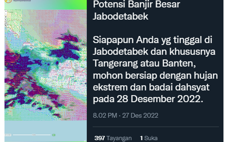
"The potential for major flooding in Jabodetabek. Whoever you live in Greater Jakarta, and especially Tangerang or Banten, please be prepared for extreme rain and violent storms on December 28, 2022," Erma said in a post on Twitter, Tuesday (27/12/2022).
The results of the BMKG analysis show that there is no potential for a storm to occur on December 28.
"The weather forecast on December 28, 2022 generally is rain with moderate to heavy intensity, but not a storm," said BMKG Deputy for Meteorology Guswanto in his statement, Tuesday (27/12/2022).
Throughout Wednesday (28/12/2022) in several areas of Jakarta, there were no major storms as predicted by BRIN researchers. However, it is raining in a number of areas in DKI Jakarta according to the BMKG weather forecast.
Based on monitoring, in the Ancol area, North Jakarta, it has been raining since 10.00 WIB.
The rain was light at first and stopped for a while. However, at 12.00 WIB it started to rain heavily and was accompanied by wind. Then the rain stopped at 16.00 WIB and again flushed several areas of North Jakarta at 17.00 WIB.
The rain also stopped for a while, but fell again at night. From 19.30 WIB to 21.00 WIB.
Rain with moderate intensity accompanied by wind again flushed the Gambir area. Meanwhile in Grogol, West Jakarta, it rained around 11.00 WIB. Heavy rain flushed the area until the afternoon.
In East Jakarta, rain with a little wind occurred in the Jatinegara, Kramat Jati and Pasar Rebo areas from 08.00 WIB to 09.30 WIB.
Major Storms, Different Methods of Analysis
Coordinator of BMKG Data and Information Field Class I Geophysics Station Tangerang, Dinda Ayu said, differences in the predictions of BRIN and BMKG could occur because the methods used to carry out the analysis were different.
"Even though in one indicator the atmosphere is the same that we are monitoring, it's the same, but with a different method the results are different," said Dinda, Tuesday (27/12/2022).
Erma's prediction, based on data analysis from the satellite early warning system (Sadewa). In a thread on Twitter, Erma explained, a violent storm from the sea will move to land via two paths.
First, from the west through the westerly wind that brings rainstorms from the sea (western burst). Second, from the north through a strong surface wind (northerly).
"So that there will be two supplies of rain or two supplies of storms which tomorrow will accumulate in the Jabodetabek area," said Erma.
Meanwhile, said Dinda, currently BMKG no longer uses Sadewa in monitoring weather developments. The weather forecast issued by the BMKG is made based on the latest weather observations, analysis of low-resolution model outputs, and forecasters' experience in analyzing the weather.
The use of forecasters' analytical skills and experience in providing an assessment of weather predictions causes weather forecasting to be classified as a subjective method.
Apart from using predictor analysis, weather forecasting in an area also uses various tools such as weather radar, lighting detectors (lightning detectors), Automatic Rain Gauge (ARG) and Automatic Weather Station (AWS). [DDHK News]